Pre-Columbian Transatlantic Travel?
December 27, 2022
“You know of Piri Reis?”
“You had a book on him in your room.”
“I did, didn’t I,” she laughed. “Well, his maps of the New World were based on much older ones I’m sure..."
Pre-Columbian travel between Europe and the New World is by no means unlikely, and Levantine tin traders around the time of Christ would have been strong candidates to know the route if their Mediterranean predecessors such as the Minoans had indeed used America as a source of copper for their bronze (we will publish some notes on Great Lakes copper in this Beyond the Mystery section soon).
A sophisticated clockwork navigation aid, such as the ‘Star Sailor’ Angel describes, would certainly have helped with transatlantic voyages, and one did indeed exist, an ‘Orrery’ known as the Antikythera Mechanism found in a Greek shipwreck dating from before the time of Christ.
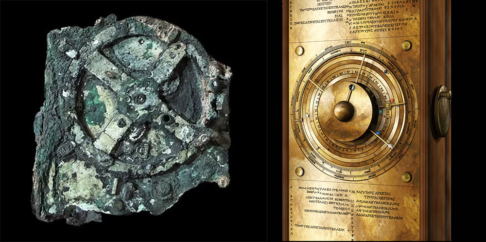
The Antikythera Mechanism as it was found and as recently reconstructed.
This device was capable of predicting the movement of celestial bodies with great accuracy, using finely crafted differential gearing, and is sometimes described as ‘prochronistic’ (so way ahead of its time). Clockwork of such complexity only began to be made again about fifteen hundred years later, with the astronomical knowledge needed to build the Antikythera Mechanism (including understanding of elliptical planet orbits), being properly rediscovered more than three hundred years after that. What is most striking to me about this device though, is evidence of mass production, clear to see from the way the parts are machined without error (no mistakes, so the makers had lots of practice). It follows that these ‘Star Sailors’ must have been numerous and whilst probably expensive, readily available, so that every ship could have one.
Maps made by the Ottoman Admiral Piri Reis (which, as Angel tells Sangster, were discovered in Istanbul’s Topkapi Palace in 1929, and can still be seen there today), are allegedly based not only on the charts of Christopher Columbus but also maps from the time of Alexander the Great, implying that ancient European navigators may indeed have possessed knowledge of America.

A fragment of a Piri Reis map from 1513 showing the coastline of America (bottom left).
There is also plenty of anecdotal evidence cited for travel between Europe and America in ancient times (alleged traces of tobacco in Egyptian sarcophagi and so on), and more substantive evidence that later Europeans (such as the dark ages Irish monk Brendan and Viking Leif Ericson), also journeyed to the New World well before Columbus.
Mediterranean-American trading links from the time of Christ therefore seem plausible, although (as far as I know), we have yet to see any conclusive proof.